
MAGIC Historical Map Collection - United States
Included below are select maps from the University of Connecticut Library Map and Geographic Information Center - MAGIC collections which have been digitized. This collection will continue to grow so be sure to check back often. A copy of each map can be downloaded for use in your research or projects by clicking on the title or the view and download map image.
United States
Title |
Location | Year | Scale | Cartographer/ Source |
Metadata | Series # | Preview in Google Earth |
View & Download Map |
|---|---|---|---|---|---|---|---|---|
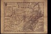
| A general map of the middle British colonies, in America. | United States | 1755 | s2250 | Evans | Coming Soon | 1 |  |
 |
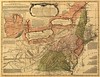
| A general map of the middle British colonies in America. | United States | 1771 | s2250 | Evans | Coming Soon | 1 | |
 |
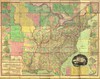
| United States of America. | United States | 1834 | s2000 | Tanner | Coming Soon | 1 | |
 |
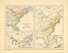
| Map page of Section LXXXVIII The United States of America after the Treaty of 1783 from Part XXV of Historical atlas of modern Europe from the decline of the Roman empire : comprising also maps of parts of Asia and of the New world connected with European history. | United States | 1834 | s2000 | Tanner | Coming Soon | 1 | |
 |
MAGIC also offers maps for the Midwest, Northeast Atlantic, New England, Connecticut, and Connecticut Towns within the United States.