
Connecticut Historical Aerial Photography
The University of Connecticut Library Map and Geographic Information Center - MAGIC, in collaboration with the Connecticut State Library, UConn Center for Land Use and Research (CLEAR), and the Connecticut Department of Energy and Environmental Protection are focused on digitizing and providing public access to aerial photography for the state of Connecticut. Included below are aerial photography collections which MAGIC, CT ECO, and the Connecticut State Library provide for the state of Connecticut.
Connecticut Environmental Conditions Online (CT ECO) Aerial Photography Viewer
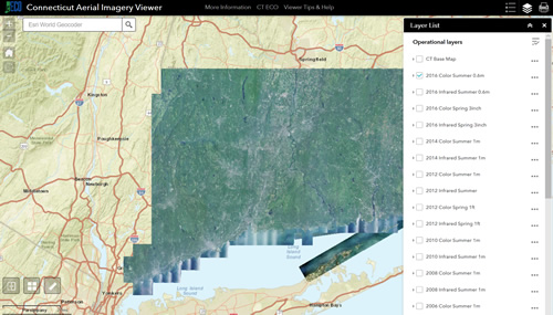 CT ECO is an interactive web mapping interface which allows users to view aerial photography mosaics and GIS data layers via the web. This interface allows users to generate customized maps for locations within Connecticut. CT ECO is a service provided by the Connecticut Department of Energy and Environmental Protection (CT DEEP) and UConn's Center for Land Use and Research (CLEAR).
You can view the following data via CT ECO:
Aerial Photography:
- 1990 Orthophotos
- 2004 Orthophotos
- 2006 Orthophotos
- 2008 Orthophotos
- 2009 Orthophoto - CRCOG
- 2010 Orthophotos
- 2012 Orthophotos
- 2014 Orthophotos
- 2016 Orthophotos
Infrared Aerial Photography:
- 2008 Orthophoto - Infrared
- 2010 Orthophoto - Infrared
- 2012 Orthophoto - Infrared
- 2014 Orthophoto - Infrared
- 2016 Orthophoto - Infrared
Additional Maps:
CT ECO also offers Map Services that users of ArcGIS and other GIS software applications can access. For details on the CT ECO Map Services visit: http://cteco.uconn.edu/map_services.htm
Connecticut Historical Aerial Photography - MAGIC
MAGIC in collaboration with the Connecticut Department of Energy and Environmental Protection (CT DEEP) has developed a series of historical aerial photography indexes to assist users with locating aerial photography for an area of interest in Connecticut, Each of these aerial photography indexes can be viewed within GIS software, Google Earth, or users can locate an aerial photo by using the Map Preview link. Several of these aerial photography indexes also include direct links to a pdf and full-quality TIFF version of each photograph. Included below is a listing of the Aerial Photography Indexes available from MAGIC.
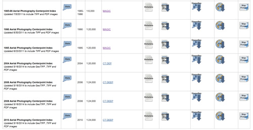
Aerial Photography Index Collections:
- 1934 Aerial Photography
- 1951-1952 Aerial Photography
- 1957 Aerial Photography - Middlesex County
- 1963 Aerial Photography - Tolland, New London, and Windham County
- 1965 Aerial Photography
- 1970 Aerial Photography
- 1985-1986 Aerial Photography
- 1990 Aerial Photography
- 1995 Aerial Photography
- 2004 Aerial Photography
- 2006 Aerial Photography
- 2008 Aerial Photography
- 2010 Aerial Photography
Infrared Aerial Photography Index Collections <9/19: access to infrared photos temporarily unavailable>:
- 1974 Coastal Infrared Aerial Photography
- 1980 Coastal Infrared Aerial Photography
- 1981 Coastal Infrared Aerial Photography
- 1986-1987 Coastal Infrared Aerial Photography
- 1990 Coastal Infrared Aerial Photography
- 1995 Coastal Infrared Aerial Photography
Note: To obtain digital images for 1969 once you have identified aerial photos you wish to use, just email us at MAGIC magic@uconn.edu with the photo number(s) and year(s) and we will send you a copy of the individual aerial photos.
Connecticut Historical Aerial Photography - Connecticut State Library
The Connecticut State Library (CSL) includes several aerial photography collections electronic and print formats. Included below is a brief outline of the aerial photography collections available from the Connecticut State Library. 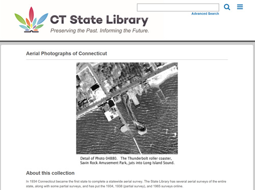
Online Aerial Photography Collections:
Print Aerial Photography Collections:
- 1934 Aerial Photography
- 1938 Hurricane Damage Aerial Photography
- 1951-2 Aerial Photography
- 1965 Aerial Photography
- 1970 Aerial Photography
- 1975 Aerial Photography
- 1980 Aerial Photography
- 1985 Aerial Photography
- 1990 Aerial Photography
- 1995 Aerial Photography
- 2000 Aerial Photography
- Other aerial photo collections
Connecticut Historical Aerial Photography Mosaic Map Mash-ups
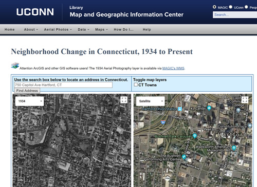 MAGIC has created a series of Aerial Photography Mosaic Map Mash-ups which enable users to view aerial photography mosaics, search for a particular location by street address, and view different years of aerial photography mosaics for a particular location. These maps utilize aerial photography imagery from CTECO's Map Services and MAGIC's Web Map Service (WMS) to create custom Google Maps Mash-ups to enhance the usability of these collections.
Aerial Photography Mosaics Available include:
- 1934 Fairchild Survey Aerial Photography
- 1990 Aerial Photography
- 2004 Aerial Photography
- Recent Google Satellite imagery
The Connecticut Aerial Photography Mosaics Map Mash-up also allows users to view imagery for a particular location as well as setting the default aerial photography layer to view. Details on creating a custom bookmark for this map mash-up are included below the interactive map.