MAGIC Historical Map Collection - New England United States
Included below are select maps from the University of Connecticut Library Map and Geographic Information Center - MAGIC collections which have been digitized. This collection will continue to grow so be sure to check back often. A copy of each map can be downloaded for use in your research or projects by clicking on the title or the view and download map image.
New England
Title |
Location |
Year |
Scale |
Cartographer/
Source |
Metadata |
Series # |
Download
TIFF
|
View & Download Map |
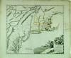
| A map of New England, New York, New Iersey, Mary-Land & Virginia. |
New England, New York, New Jersey, Maryland, &Virginia |
1676 |
s1500 |
Morden |
|
1 |
 |
 |
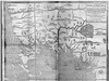
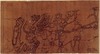
| A map of New-England, being the first that ever was here cut, and done by the best pattern that could be had, which being in some places defective, it made the other less exact: Yet doth it sufficiently show the situation of the country & conveniently well the distances of places. |
New England |
1677 |
s00 |
Hubbard |
|
1 |
|
 |
| Novi Belgii Novæque Angliæ : nec non partis Virginiæ tabula multis in locis emendata. |
New England |
1685 |
s00 |
Visscher |
|
1 |
|
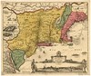 |
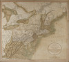
| A map of the most inhabited part of New England, containing the provinces of Massachusets Bay and New Hampshire, with the colonies of Conecticut and Rhode Island, divided into counties and townships: The whole composed from actual surveys and its situation adjusted by astronomical observations. |
New England |
1755 |
s150 |
Jeffreys |
|
1 |
|
 |
| Marche de l'armée française de Providence à la Rivière du Nord : 1ere feuille. |
New England |
1781 |
s200 |
Rochambeau |
|
1 |
|
 |
| Marche de l'armée française de Providence à la Rivière du Nord : 2e feuille. |
New England |
1781 |
s200 |
Rochambeau |
|
2 |
|
 |
| Marche de l'armée française de Providence à la Rivière du Nord : 3e feuille. |
New England |
1781 |
s200 |
Rochambeau |
|
3 |
|
 |
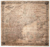
| A new map of part of the United States of North America : containing those of New York, Vermont, New Hampshire, Massachusets [sic], Connecticut, Rhode Island, Pennsylvania, New Jersey, Delaware, Maryland and Virginia. From the latest authorities : 1811 |
New England |
1811 |
var |
Cary |
Coming Soon |
1 |
|
 |
| Colton’s New Steel Plate Map of New England (Reproduced from the original map at Martayan Lan Fine Antique Maps, New York. ) |
New England |
1860 |
var |
Colton |
|
1 |
|
 |
Back to top
MAGIC also offers maps for the United States, Midwest, Northeast Atlantic, Connecticut, and Connecticut Towns within the United States.
