
MAGIC Historical Map Collection - Midwest United States
Included below are select maps from the UConn Library Map and Geographic Information Center - MAGIC collections which have been digitized and made available via the UConn Library Archives & Special Collections. A copy of each map can be downloaded for use in your research or projects by clicking on the title or the view and download map image.
Midwest United States
Title |
Location | Year | Scale | Cartographer/ Source |
Metadata | Series # | Download TIFF |
View & Download Map |
|---|---|---|---|---|---|---|---|---|
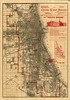
| Columbian Visitors' Association: The "South Shore". | Chicago, Illinois | 1890 | var | Unknown | Coming Soon |
1 |  |
 |
| 1899 Railroad map of Ohio / published by the state, prepared under the direction of R. S. Kayler, commissioner of railroads and telegraphs, Columbus, Ohio. | Ohio | 1899 | 1:500,000 | Kayler | 1 | |
||
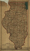
| Department of the Interior, General Land Office, Fred Dennett, Commissoner. State of Illinois. Compiled from the official Records of the General Land Office and other sources, under the direction of I.P. Berthrong, Chief of Drafting Division G.L.O. 1911. | Illinois | 1911 | var | Unknown | Coming Soon |
1 | Coming Soon |
 |
| Map Showing the Great Coal Fields, Natural Gas Fields, Steam and Electric Railroads: and All Important Towns, Villages, and Streams Tributary to Columbus Within a Radius of 70 miles | Columbus, Ohio | 1911 | var | Unknown | 1 | |
MAGIC also offers maps for the United States, Northeast Atlantic, New England, Connecticut, and Connecticut Towns within the United States.