
Racial Change in the Hartford Region, 1900-2010
Click Map to Display Town & Data
Search Hartford area
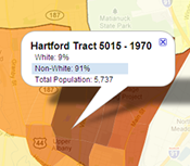
% White Population 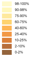

Currently Viewing: 1900

Drag the time slider (or click on a decade) to view changes in the racial population of the Hartford region over time. For more detail, click on any area to view the town name and tract-level census data.
Read more at On The Line.
| Sources | How to Cite | ||||||
|---|---|---|---|---|---|---|---|
|
Coming soon!
|
APA 6th Edition
University of Connecticut Libraries Map and Geographic Information Center - MAGIC. (2012).Racial Change in the Hartford Region, 1900-2010. Retrieved from http://magic.lib.uconn.edu/otl/timeslider_racethematic.html.
Chicago 16th edition [author-date]
University of Connecticut Libraries Map and Geographic Information Center - MAGIC. 2012. "Racial Change in the Hartford Region, 1900-2010." Accessed
June 20. http://magic.lib.uconn.edu/otl/timeslider_racethematic.html.
MLA 7th edition
"Racial Change in the Hartford Region, 1900-2010." University of Connecticut Libraries Map and Geographic Information Center - MAGIC . Web. 20 Jun. 2012. <http://magic.lib.uconn.edu/otl/timeslider_racethematic.html>.
|
||||||


| Project Funding |
|---|
| Funding for this project was provided by the National Endowment for the Humanities (NEH). Any views, findings, conclusions or recommendations expressed in this website do not necessarily represent those of the NEH. |