Federal HOLC "Redlining" Interactive Map, Hartford area, 1937
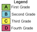 Click colored regions to view pages from the Home Owners' Loan Corporation (HOLC) appraisal report, which this federal agency created with local lenders to evaluate the "trend of desirability" in residential areas in Hartford and over 200 other cities during the late 1930s. The HOLC color-coded map portrayed the highest grade (A) in green and the lowest grade (D) in red. This government agency considered not only housing conditions but also the "social status of the population," and downgraded neighborhoods with non-white, immigrant, and poor residents. In later decades, these actions became associated with the discriminatory practice of "redlining." See also the two original maps (Hartford-West Hartford and East Hartford), the full appraisal report, and a searchable spreadsheet. Read more in On The Line.
Use the search box below to locate an address in the Hartford area.
Toggle map layers
HOLC Areas, 1937
HOLC Areas, 1937
| Sources | How to Cite | ||||||
|---|---|---|---|---|---|---|---|
|
Residential Security Maps (Hartford-West Hartford and East Hartford) and Area Descriptions for Hartford area, Connecticut, 1937. Home Owners’ Loan Corporation, box 64, City Survey Files, Record Group 195: Records of the Federal Home Loan Bank Board, National Archives II, College Park, Maryland. 1934 Connecticut Aerial Photography provided by the Connecticut State Library 2008 NAIP Imagery Provided by the Connecticut Department of Environmental Protection |
APA 6th Edition
University of Connecticut Libraries Map and Geographic Information Center - MAGIC. (2010). Federal HOLC "Redlining" Interactive Map, Hartford area, 1937. Retrieved from http://magic.lib.uconn.edu/otl/holc_mashup.html.
Chicago 16th edition [author-date]
University of Connecticut Libraries Map and Geographic Information Center - MAGIC. 2010. "Federal HOLC "Redlining" Interactive Map, Hartford area, 1937." Accessed
September 24. http://magic.lib.uconn.edu/otl/holc_mashup.html.
MLA 7th edition
"Federal HOLC "Redlining" Interactive Map, Hartford Area, 1937." University of Connecticut Libraries Map and Geographic Information Center - MAGIC . Web. 24 Sept. 2010. <http://magic.lib.uconn.edu/otl/holc_mashup.html>.
|
||||||
| Data (Excel) | Documents (pdf) |
Google Earth Layer (kml) | East Hartford Map (tif) | Hartford - West Hartford Map (tif) | Shapefile (CT State Plane) |
Shapefile (WGS 84) |
|
 |
 |
|
|||||
| Credits |
|---|
Benjamin Spaulding (GISDoctor.com)Jack Dougherty (Trinity College)Thomas Bachant, Curtis Denton, Bill Miller, Joshua Strunk, and Michael Howser (University of Connecticut Libraries MAGIC)Funding for this project was provided by the National Endowment for the Humanities (NEH). Any views, findings, conclusions or recommendations expressed in this website do not necessarily represent those of the NEH. |